Find the solution with TZ iBoat, the latest generation of marine navigation apps
All the information about TZ iBoat features, instruments and compatibilities, charts and weather data, are available here. More than 20 questions have been answered so that you can make the most of your experience using TIMEZERO’s coastal sailing iPad solution.
You can try and use TZ iBoat for free using a basic map (Open Street Map):
- Plot your position in real-time on a basic map or satellite picture (*) using your device’s internal GPS, Bluetooth GPS or NMEA0183 Wireless Gateway.
- Navigation in 2D or 3D Perspective.
- Route Planning
- Trail and track recording
- Sensor compatibility to display additional real-time information (Heading, Depth, Wind and Sea Surface Temperature) when connected to a NMEA0183 Wireless Gateway.
- Real-time local weather and weather trends
- Unlimited GFS weather forecasts.
- Tides and Currents database
- The Trip function records all your data (such as position, speed, depth, wind...) and combines them with any photo, catches, or events you may have created during your navigation.
For offline use and safe navigation, you can purchase a TZ MAPS nautical chart for your area (In-App subscription). TZ MAPS combines several data types: Raster, Vector, detailed land information, high-resolution satellite photos, high resolution Bathymetry in addition to new advanced features! The list of charts that can be purchased is available below: https://mytimezero.com/tz-iboat/charts-directory
TZ iBoat also offers the optional features below:
- AIS integration when connected to a NMEA0183 Wireless AIS Receiver, and also beyond your local receiver’s range by connecting to our global AIS network via the Internet (In-App purchase)
- Radar overlay with the Furuno DRS4W “1st Watch” Radar (In-App purchase)
- Sounder overlay with Furuno’s FCV-600 and FCV-800 Fish Finder for remote display and control via Wireless LAN (In-App purchase)
- Premium High-Resolution Weather Forecasts (In-App subscription)
(*) Internet Access required for streaming basic map and satellite photos
TZ iBoat requires an iPhone or an iPad running iOS 14.2 at minimum. If you want to use TZ iBoat on an iPad, it is recommended to get an iPad with Cellular connectivity to benefit from the device’s internal GPS. For “Wi-Fi Only” iPad, a separate Bluetooth GPS will be required.
TZ iBoat displays weather forecast overlaid directly on the chart (in color, with particle animation or using arrows). Weather forecast can be cached for offline use. The GFS model is free to use. Additional High-Resolution models are available as In-App subscription.
When you have an Internet connection, the Weather NavData displays the local weather either from airports or from permanent weather observation stations (METAR). The station displayed in TZ iBoat is the one that is the closest to your current GPS position.
No, currently TZ iBoat is only available on iOS.
The easiest option is to use an iPad with a built-in GPS receiver (any iPad with cellular connection). However, if you have a “Wi-Fi only” iPad (without an integrated GPS receiver), you can either purchase a Bluetooth GPS (compatible with the Apple Core Location Service) or use and an external NMEA0183 GPS connected to a Wi-Fi Gateway (see below).
Yes, it is possible to connect TZ iBoat to external instruments that use NMEA0183 over Wi-Fi. TZ iBoat can currently decode the following data:
- Position (GLL, GGA, RMC, VDO)
- Course and Speed Over Ground (RMC, VTG, VDO)
- Heading (HDG, HDM, HDT, VHW, PFECATT, VDO)
- Depth (DBT, DPT)
- Wind (MWV, MWD)
- Sea Surface Temperature (MDA, MTW)
- AIS (VDM) (*)
TZ iBoat is compatible with any Wi-Fi Gateway that supports NMEA0183 sentences over TCP or UDP. Although TZ iBoat is not directly compatible with NMEA2000 data, all NMEA2000 to Wi-Fi gateways can convert NMEA2000 data into NMEA0183 data before sending it over UDP or TCP. Here are some devices that have been tested successfully with TZ iBoat:
- ShipModul MiniPlex-2Wi NMEA 0183 Multiplexer with WiFi - More Information
- Digital Yacht WLN10 WiFi NMEA 0183 Server - More Information
- Actisense W2K-1 NMEA2000 to Wi-Fi Gateway - More Information
- Comar i300W NMEA to Wi-Fi Interface - More Information
- Yacht Devices YDWG-02 NMEA2000 Wi-Fi Gateway - More Information
- Vesper XB-8000 AIS Transponders and Multiplexer (*) - More Information
- Digital Yacht iAIS Receiver (*) - More Information
- Digital Yacht Nomad AIS Transponder (*) - More Information
Usually, the NMEA0183 Wi-Fi Gateway creates its own wireless network access point. The iPhone or iPad must be set up to join this Wi-Fi network. If the Wi-Fi Gateway is set to output NMEA0183 sentences over Wi-Fi using the UDP protocol, you only need to enter the UDP port number in TZ iBoat. If the TCP protocol is used instead, you need to enter the TCP port number and the IP address of the Wi-Fi Gateway in TZ iBoat. For most applications, we recommend using the UDP protocol whenever possible.
(*) AIS targets can only be displayed when the optional AIS module is purchased
No, TZ iBoat is only compatible with NMEA0183 sentences but note that all Wi-Fi Gateways will directly convert NMEA2000 PGN to NMEA0183 sentences, and then transmit that information onto a UDP or TCP port. This allows TZ iBoat to display instruments data even if the instruments themselves are only compatible with NMEA2000.
Yes, if you enable track recording or activate a route, TZ iBoat will continue to record your position even if the iPhone or iPad goes into sleep mode. You also have the possibility to forbid sleep mode from the “General” Options of TZ iBoat.
TZ MAPS charts can be purchased on TZ iBoat. TZ MAPS includes Raster, Vector, detailed land information, high-resolution satellite photos and high-resolution Bathymetry. Vector charts (or electronic charts) are available worldwide. Raster charts (that look like traditional paper charts) are sourced from local hydrographic offices and are available in selected areas only. Note that chart purchase is a one-year subscription. The list of chart areas is available below: https://mytimezero.com/tz-iboat/charts-directory
After purchasing the chart, you can download detailed nautical charts by zooming in (streaming the data) or by caching areas from the "Offline Charts & Weather" menu of TZ iBoat. After one year, the subscription will be renewed automatically unless auto-renew is turned off at least 24 hours before the end of the current period. If you decide to not renew the subscription, charts will reside on your device even after expiration with the latest update done during subscription period.
After purchasing a Nautical Chart area, you will be able to store the chart locally for offline use by clicking on "Offline Charts & Weather" and selecting the cells you want to download on your device.
Note: It is not possible to store the Satellite Photos locally. You need to have an Internet connection in order to stream Satellite Photos.
Yes, you can load and use TZ iBoat on up to 5 devices (iPhone or iPad). Just make sure to sign in on TZ iBoat with the same “My TIMEZERO” account.
Charts are automatically updated during the subscription period (*). After this period, if you have cancelled your subscription, you will not be able to download or update the chart anymore. Downloaded charts will remain usable on your device with the latest update done during subscription period, but if you reset your device or want to use a new device, you will have to renew your subscription to be able to download the charts again.
(*) Chart update frequency varies according to the chart manufacturer.
Yes! The TZ MAPS chart you purchased on those platforms can be used on TZ iBoat.
The DRS4W Radar creates its own wireless network access point. The iPhone or iPad must be setup to join the Radar’s wireless network. All DRS4W Radars create a network with an identifier (SSID) starting with “DRS4Wxxxxxxxx”. The wireless network is protected using a password (WPA2-Personal) which is unique to each DRS4W Radar. Once connected to the Radar network, open TZ iBoat and select “Radar” or “Chart + Radar” from the “Layer” button.
No, the DRS4W can only create its own wireless network and cannot join any existing wireless network. Please also note that the SSID and Password used to connect to the DRS4W network are fixed and cannot be changed.
You need to make sure that the Wi-Fi Gateway you want to use can join an existing WIFI network. This means that you should be able to program the Wi-Fi Gateway to connect to the DRS4W network by entering the DRS4W SSID and Password:
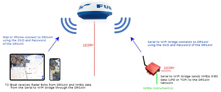
If the Wi-Fi Gateway is set to output NMEA0183 sentences over Wi-Fi using the UDP protocol, you only need to enter the UDP port number in TZ iBoat.
If the Wi-Fi Gateway is using the TCP protocol, you need to enter the TCP port number and the IP address of the Wi-Fi Gateway in TZ iBoat.
In this case (when using TCP), the Wi-Fi Gateway must be set to use a fixed IP address on the DRS4W network (172.31.x.x). We recommend setting the IP address of the Wi-Fi Gateway to 172.31.3.100 with a subnet mask of 255.255.0.0.
Most of the Wi-Fi Gateways can join an existing Wi-Fi network, but you should check directly with the manufacturer.
While recommended, an external heading sensor is not mandatory for the overlay of Radar echoes on the chart. TZ iBoat can use its internal (or external) GPS Course Over Ground (COG) to align the Radar on the chart. Note that the radar echo will appear with high transparency if your vessel is moving below 1Kn (to indicate that the Heading derived from your course over ground is inaccurate).
TZ iBoat will be able to adjust all the Radar user parameters so you don’t have to switch between multiple Apps on your device.
Note: Only the initial Blank Sector and radar alignment adjustments will need to be made from the standalone FURUNO App.
No, this is not supported by the DRS4W because a background App must “lock on” the DRS4W connection, preventing the other App from receiving the data. However, you can use two separate devices at the same time (for example your iPhone and your iPad).
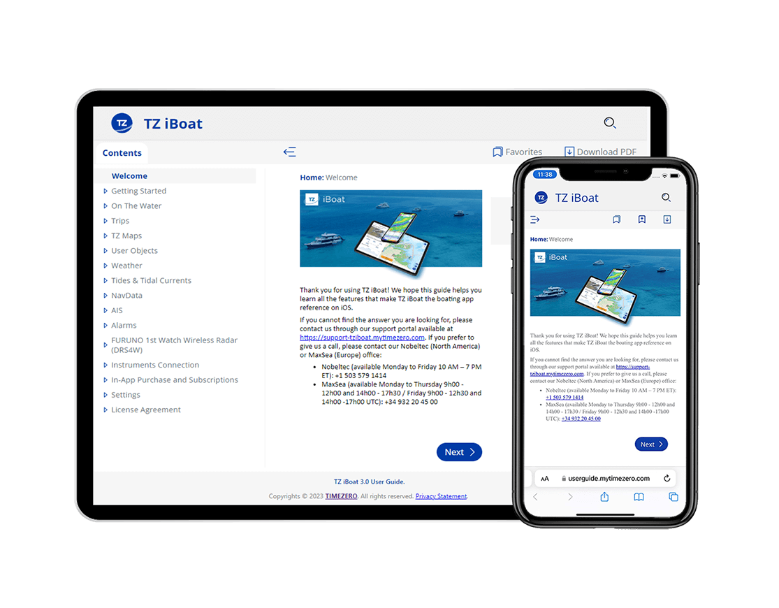
This complete user guide and manual for TZ iBoat contains everything you need to know about our app. Master your boating and get out on the water in as safe and exciting a way as possible.

Download TZ iBoat - Marine Navigation!